Day 1 – The Long March to the High Camp
Route: Old Moses Camp (3,300m) – Liki North Valley – Mackinder’s Valley – Shipton’s Camp (4,236m).
Metrics:
- Distance: Approx. 16 km (via Liki North detour).
- Elevation Gain: +936m.
- Hiking Time: 7 – 9 hours.
- Zone Transition: Montane Forest -> Heath -> Moorland -> Alpine Desert.
The Launchpad: Old Moses Camp (3,300m)
The expedition commences at Old Moses Camp (also known as Judmaier Camp), situated at the edge of the forest belt. Old Moses offers the first panoramic views of the summits. Even here, the air is noticeably thinner. The vegetation is dominated by tree heather (Erica arborea) and tussock grasses. The camp itself is a functional wooden structure, a remnant of the practical, no-nonsense style of early park management.
Into the Moorlands: The Split
Leaving Old Moses, the trail ascends steadily through the heathland. The ground is often spongy, a dense mat of waterlogged vegetation and volcanic soil. About an hour into the trek, the route encounters a critical junction near the “Barrow,” a rounded elevation on the ridge.
Option A: The Direct Route. This path contours around the valley head and drops into Liki North Valley which after an ascent up the valley, drops you directly into Mackinder’s Valley. It is shorter but less scenic and offers a linear ascent profile.
Option B: The Liki North Detour. This is the chosen route for the outstanding hiker. It swings right (south), climbing over a ridge before dropping steeply into the Liki North Valley making it a strenuous and demanding route.
The Liki North Sanctuary
The descent into Liki North Valley (approx. 3,990m) is a revelation. The valley is a hidden amphitheater, sheltered from the winds. The Liki North stream, clear and freezing, cuts through the valley floor. Historically, a hut existed here (Liki North Hut), but it is now largely a ruin, used occasionally as a campsite.
This valley is a prime showcase for the Dendrosenecio keniodendron (Giant Groundsel). These towering, alien-looking plants can reach 6 meters in height. They retain their dead leaves around the trunk to insulate the water-transporting tissues inside from the freezing night temperatures, a natural “down jacket.” Walking through a grove of these giants in the mist is an eerie, Jurassic experience.
The Gatekeepers: Terer and Sendeiyo
Climbing out of Liki North, the trail crests a ridge to join the main Mackinder’s Valley path. At this juncture, the view explodes eastward. Dominating the skyline are two jagged, rocky peaks: Terer (4,714m) and Sendeiyo (4,704m).
Cultural Significance: These peaks are not merely geological features; they are characters in the Maasai history. The peaks are named after Maasai Laibons (medicine men/prophets). In the oral tradition, Sendeiyo and Lenana were the sons of the great Batian. Upon Batian’s death, a fierce rivalry for succession erupted between the brothers. Sendeiyo, the elder, was eventually defeated by Lenana, but his memory is immortalized in stone. These peaks stand as the “northern sentinels,” watching over the approaches to the sacred mountain of God (Ngai).
Visually, Terer and Sendeiyo present a rough, textured counterpoint to the glaciated smoothness of the valleys. Their rock is darker, more weathered, and they often catch the mid-day cloud, creating a dramatic interplay of light and shadow.
The Mackinder’s Valley Traverse
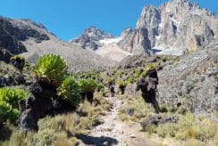
The final leg of Day 1 is a long, arduous trek up the Mackinder Valley. This valley is massive, a wide U-shaped corridor leading directly to the heart of the mountain. The scale here is deceptive; boulders that look close take twenty minutes to reach.
The vegetation transitions from the giant heathers to the high-altitude zone. The Lobelia telekii, with its furry, ostrich-plume rosette, becomes the dominant species. This fur traps a layer of air, insulating the plant against the night frost; an adaptation mirrored by the hikers putting on their fleece layers as the sun dips behind the ridges.
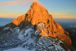
To the front, the main peaks of Batian and Nelion grow impressively large. We are approaching the north face, a sheer wall of rock that holds some of the most classic technical climbing routes, including the “North Face Standard Route,” first climbed by Shipton and Wyn-Harris.
Shipton’s Cave and Camp
Just before the final steep ascent to the camp, the trail passes a significant historical landmark: Shipton’s Cave. Located in a rock wall to the left of the path, this cave is a testament to the “Golden Age” of exploration.
Eric Shipton: The cave is named after Eric Shipton, the British mountaineer who used it as a bivouac during his extensive explorations of the mountain in 1929 and the early 1930s. Shipton is a legend in climbing circles, known for his alpine style “travel light” philosophy and his later role in the 1953 Everest reconnaissance.
The Mau Mau: During the 1950s, these high-altitude caves took on a darker utility. They served as hideouts and logistical bases for the Mau Mau freedom fighters during the uprising against British colonial rule. The caves provided shelter from aerial bombardment and patrols. Entering the cave today, one can often find soot on the ceiling, a lingering ghost of the fires burned by men freezing in the dark for a cause.
A final, lung-busting climb brings the team to Shipton’s Camp (4,236m). Nestled in a bowl beneath the peaks, the camp is a cluster of green-roofed buildings. It is stark, cold, and utterly magnificent. The summit of Point Lenana is visible to the east, a daunting scree slope that will be the morning’s battleground.
Evening Protocol: Dinner is high in carbohydrates. Hydration is a must. Alcohol is strictly prohibited due to its respiratory depressant effects. Hikers retire early, usually by 8:00 PM, to snatch a few hours of fitful sleep in the thin air.
Part IV: Day 2 – The Summit, The Tarns, and The Descent
Route: Shipton’s Camp – Harris Tarn – Point Lenana – Mackinder’s Valley – Old Moses – Sirimon Gate.
Metrics:
- Summit Ascent: +749m.
- Total Descent: -2,385m.
- Hiking Time: 12 – 14 hours.
The Alpine Start (02:30 AM)
The guide’s knock comes at 2:30 AM. The air inside the bunkhouse is warm, the Shipton bunkhouses are surprisingly well insulated; outside, it is freezing. Temperatures can range from -5°C to -15°C. The sky, unpolluted by light, is a dense canopy of stars, with the Milky Way arching over the silhouette of Batian.
The ascent begins immediately on a steep scree slope behind the camp. This is the “stony quarry,” a notorious section of loose gravel that slides underfoot. In the cone of the headlamp, the world shrinks to the boots of the person in front. The pace is slow, the “pole pole” (slowly, slowly) rhythm essential for altitude management.
The High Tarns: Mirrors of the Mountain
As the trail climbs higher, passing the 4,600m mark, it enters a zone of glacial tarns. These small lakes are fed by the melting ice of the glaciers. In the pre-dawn darkness, they appear as flat, black voids, but as the light grows, their true nature is revealed.
- Harris Tarn (4,750m): The route to Lenana passes directly by this tarn. It is a bleak, desolate sheet of water, often frozen at the edges. It sits in a high bowl, collecting the runoff from the north face of Lenana.
- Kami Tarn: Visible if one looks towards the Hausberg Col to the right. This tarn is associated with the technical climbers heading for the North Face routes. It has a rugged, isolated beauty.
- Simba Tarn: Located near the Simba Col, passed on the left. It is another jewel in the necklace of water bodies that ring the central peaks.
These tarns are glacial relics, filling the depressions gouged out by the ice. They are lifeless in the macro sense but support specialized microscopic ecosystems adapted to extreme UV radiation and freezing cycles.
The Summit Push: Point Lenana (4,985m)
The final ascent from Harris Tarn traverses the north ridge of Lenana. The path navigates through rocky outcrops and snow patches. The breathing becomes laboured; every step requires a conscious act of will.
Arrival at the summit of Point Lenana (4,985m) coincides with sunrise. This is the payoff.
The Panorama:
- Kilimanjaro: To the south, 320 km away, the dome of Kilimanjaro floats above the haze on the horizon. Seeing the roof of Africa from the second-highest point is a rare privilege, dependent on the clarity of the morning air.
- Batian and Nelion: The most imposing view is immediate. To the west, the sheer east face of Nelion rises like a fortress wall. The Gate of Mists, the jagged notch separating Nelion from Batian, is clearly visible. One can see the hanging remnant of the Lewis Glacier, a shrinking sheet of ice that once dominated this face.
- The Gorges Valley: Looking down the Chogoria side (east), the cliffs drop vertically into the Gorges Valley. From this vantage point, one can see Hall Tarns perched on the precipice, and far below, the glittering surface of Lake Michaelson, perhaps the most beautiful lake on the mountain.
- The Aberdares: To the west and north, the rolling ranges of the Kenyan highlands stretch out, a patchwork of green against the morning gold.
The summit ceremony is brief, photos, congratulations, before the cold forces a retreat.
The Descent: A Study in Gravity
The descent is where the 2-day itinerary extracts its toll. Hikers must drop nearly 2,400 meters before the day is done.
- The Scree Run: The descent back to Shipton’s is a controlled slide down the scree. What took three hours to climb takes 45 minutes to descend. The knees absorb the impact of gravity.
- Breakfast at Shipton’s: A brief respite to refuel. The appetite may be suppressed by altitude, but eating is mandatory for the energy required for the long walk out.
- Shipton’s Caves Revisited: On the way out of Shipton’s Camp, in daylight, the guide can point out the Shipton’s Caves more clearly in the valley walls. These geological features, formed by cooling lava tubes or erosion, stand as silent monuments to the mountain’s volcanic past and its human history of resistance.
The Long March to Sirimon Gate
The trek from Shipton’s back to Old Moses (14 km) retraces the previous day’s steps through Mackinder’s Valley. The beauty of the valley is now seen in reverse, with the peaks receding behind. The air becomes richer with every kilometre, bringing a return of energy and clarity.
From Old Moses, the final 9 km descent to the Sirimon Gate through the rainforest will be covered in our van.
Ecological Re-entry: The vegetation shifts from the stark moorland back to the lush bamboo and Podocarpus forest. This is the domain of the Cape Buffalo and Elephant. Hikers must remain bunched together; encountering a solitary buffalo bull in the dense brush is a genuine danger. The air grows humid, filled with the scent of damp earth and cedar. The sound of bird calls; the Turaco and the Hornbill, replaces the wind of the peaks.
Arrival at the Sirimon Gate (2,650m) marks the end of the expedition. The body is exhausted, but the spirit is filled with the grandeur of the high places.
Date Expired !
You may also like this
The Equatorial Expedition: A 48-Hour Race to the Roof of Kenya
The Roof of Kenya is Calling: A 48-Hour Odyssey to the Sky

Exploring Kang’ere Falls: A Quartet of Cascades

Mount Satima Hike via Dragon’s Pass


